460x

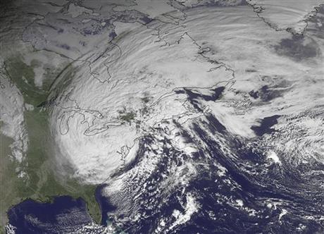
This NOAA satellite image, taken October 30, 2012, at 10:45 A.M. EDT, shows Sandy moving westward while weakening across southern Pennsylvania. Roughly 1,000 miles, Sandy was the largest Atlantic system on record. Photo courtesy National Oceanic and Atmospheric Administration (NOAA).

Leave a Reply

Fill in your details below or click an icon to log in:

WordPress.com Logo

You are commenting using your WordPress.com account. Log Out /  Change )

Twitter picture

You are commenting using your Twitter account. Log Out /  Change )

Facebook photo

You are commenting using your Facebook account. Log Out /  Change )

Connecting to %s

This site uses Akismet to reduce spam. Learn how your comment data is processed.