Tag Archives: tropical storm systems

When Real Monsters Attack

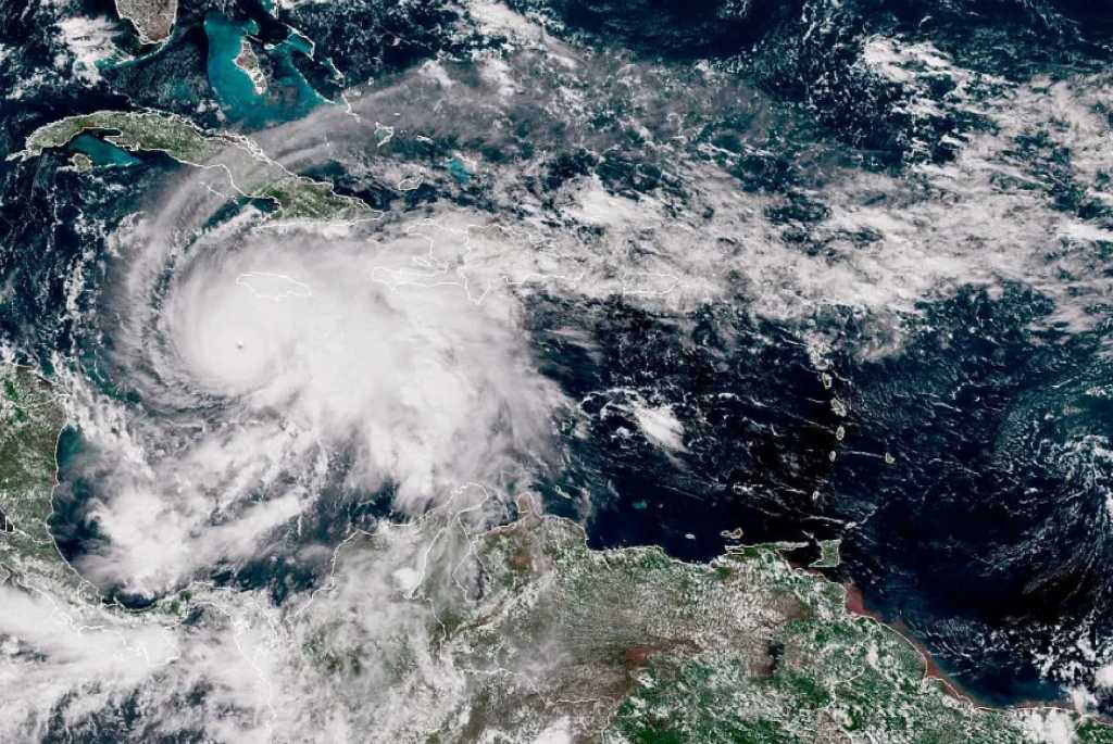
Satellite image of Melissa over Jamaica

“When I look at the cloud pattern, I will tell you as a meteorologist and professional – and a person – it is beautiful, but it is terrifying.  I know what is underneath those clouds.”

Sean Sublette, a meteorologist based in Virginia

Who needs ghosts and witches for Halloween when we have massive storm systems like Hurricane Melissa?  This past Tuesday, the 28th, Melissa plowed into Jamaica with 185-mph (298 kmh) winds.  It’s the first known Category 5 hurricane to hit Jamaica and most powerful since Gilbert in September 1988.  Gilbert held the record as the most powerful tropical storm system in recorded history, until Hurricane Patricia in the northwestern Pacific in October 2015.  Patricia produced 215-mph (346-kmh) winds and a surface pressure of 872 millibars (mb).  That pressure is the second lowest on record with Typhoon Tip producing 870 mb in October 1979.  (Tip boasted 190-mph winds.)

These storm systems – already the most powerful tempests on Earth – are getting worse.  In September 1995 Tropical Storm Opal developed in the Bay of Campeche and slammed into Florida’s west coast as a Category 4 hurricane.  It was the first time since U.S. meteorologists began naming these storms in 1953 that the Atlantic-Caribbean group reached the letter ‘O’.

That year, 1995, produced a total of 21 named systems; the greatest number since the 20 total systems (albeit unnamed) in the region in 1933.  All those records, however, shattered in 2005 when the Atlantic-Caribbean produced an unprecedented 28 tropical storm systems.  For the first time since 1953, meteorologists had to resort to the Greek alphabet for storm names.

The 2005 Atlantic-Caribbean hurricane system was most likely foretold in March 2004, when a squall nicknamed “Catarina” developed in the southwestern Atlantic and hit Brazil as what would be considered a Category 1 hurricane.  This was truly anomalous as full-fledged hurricanes rarely form in the Southern Atlantic because of cooler sea surface temperatures and strong vertical wind shear.

Tropical storm systems of any magnitude anywhere in the world are measured using the Saffir-Simpson Hurricane Wind Scale, which went into effect in 1973.  The U.S. National Hurricane Center (NHC) modified the system in 2009, but it’s still the standard-bearer for measuring the most powerful weather systems on Earth.

The development of Doppler weather radar in the 1970s proved to be a great leap forward for meteorology.  In September 1961 Hurricane Esther was the first tropical storm to be tracked by satellite.  Previously storms were generally followed by military reconnaissance aircraft.  But with Doppler scientists were able to trail various weather systems in real time and garner detailed information about a storm’s formation and movement.  By the 1980s, meteorologists began theorizing that tropical storm systems – especially hurricanes – follow certain pathways in the atmosphere; depending on the time of year and location of formation.  Late season hurricanes (after October 1) in the Atlantic-Caribbean, for example, tend to move eastward.

Eight years ago Hurricane Maria became one of the worst storms to rake across the Caribbean.  Puerto Rico suffered the worst of the chaos, as the storm killed over 3,000 people and costing roughly USD 90-95 billion.  It was the strongest storm to strike the island since the 1928 Lake Okeechobee Hurricane, which was also a Category 5 storm sporting a maximum wind speed of  160 mph (412 kmh) and a death toll in excess of 2,500 throughout the Caribbean and Florida.

Melissa’s strength is disturbing in that it is late in the Atlantic-Caribbean hurricane season.  In October 1998, meteorologists were stunned when Hurricane Mitch became the first Category 5 storm to develop in the region in the month of October.  Before the development of weather technology, it’s understandable that these storms would exact massive death tolls in the areas of impact.  The Great Hurricane of 1780 killed an estimated 22,000 to 30,000 people throughout the Caribbean.  Historians believe it may have achieved a maximum wind speed of 200 mph (322 kph).

To date, the deadliest hurricane to hit the United States (and the deadliest natural disaster) is still the 1900 Galveston Hurricane, which killed over 12,000 – at least 8,000 on Galveston alone.  No one knows where specifically it formed, but scientists believe it was a Category 4 storm.  They also believe it was the same storm that marched up into the central U.S., across the Arctic region and down in Siberia.  If that’s accurate, the storm wasn’t just deadly – it was truly anomalous.  The calamity was exacerbated by the lack of a cohesive warning system and geography.  Galveston is essentially a barrier island, which are narrow strips of sand that protect the mainland from the impact of powerful storms and ocean waves.  By nature they’re not designed to be developed for human habitation.  In 1900, the bulk of Galveston’s land mass rose barely above 15 feet (457 cm), and many of its streets ended at the shoreline.  In the ensuing decades Galveston officials have taken greater measures to develop a solid warning system and evacuation plans; a sea wall that extends across much of the island has helped, along with the planting of seagrass and palm trees.  The entire island has been literally lifted up by hauling in more sand and dirt.  Despite all those efforts, Galveston remains vulnerable, as evidenced by Hurricane Ike in 2008.

Technology and even the most comprehensive evacuation plans won’t save people from themselves.  Development along the coastlines of the U.S. has grown exponentially within the past 50 years.  In September 1999 Hurricane Floyd approached the Florida-Georgia border as a Category 4 and triggered the largest evacuation at the time – nearly 3 million people were ordered to move inland.  However, Floyd bypassed the area and migrated northward in the Carolinas.  Many people were upset at having to leave for a storm that missed them.  I recall one man on the national news complain that all the technology should have provided a more accurate prediction.  I looked at the TV screen and said, ‘Really?’  I personally believe that no one should ever be forced to flee their homes for a natural disaster.  If they feel they’re brave and strong enough to withstand nature’s wrath, just leave them alone!  But they also shouldn’t expect first responders to come racing to their aid.  After X hour, they’re on their own.

In June 1992, the United Nations staged the “Conference on Environment and Development” in Rio de Janeiro, Brazil.  Also known as the ‘Earth Summit’, political leaders, diplomats, scientists and many others convened to discuss humanity’s impact on the environment.  One subject that was part of the original agenda was birth control.  The premise was simple: unchecked population growth can have adverse effects on natural resources, such as clean water and air.  But just as the conference was set to begin, the Roman Catholic Church in Brazil intervened and demanded that any discussion on birth control either be limited or excluded altogether.  Despite some initial resistance, the conference organizers eventually conceded, and the Church got their wish.  Conversations on any kind of population control were all but eradicated.  Afterwards, though, the conference was declared a success.

In 1992 the global population was a little over 5.4 billion.  In 2024 it stood at approximately 8.1 billion.  In 1982 China reached an incredible milestone when it became the first country on Earth to attain a population of 1 billion.  (Various demographic studies declared that it actually had reached that number in 1980.)  Before then, China’s various efforts to control its population had catastrophic results.  In 1958 the “Great Leap Forward” was an attempt to streamline food production and distribution, but it led to the starvation deaths of up to 55 million people.  In 1979 the “One Child Per Family” policy was a more concerted effort to limit population growth, but it had an incredibly low acceptance rate, especially in rural areas where more children meant more hands to harvest crops and other food stuffs.  Its most negative impact, however, was on gender disparities.  As with many developing nations, China valued its male citizens more than females.  The “One Child Per Family” stunt culminated in the deaths of thousands of infant girls and has now made China the only country with a greater population of males than females.

In May 2000 India crossed the 1 billion citizenry mark.  By 2023 it had surpassed China in overall population.  Lack of education and comprehensive health care always has deleterious effects on a nation’s overall welfare.  Unmitigated population increases push more people into regions where they’ve never or at least rarely lived.  We’re seeing that here in the U.S., as city populations grow and begin overtaking forests and even farmland.

What does this have to do with Melissa and other tropical storm systems?  In terms of population and human interaction with nature, it means everything.  Coastal areas continue to be popular destinations for tourists and even residents.  Severe storms and rising seas are already wreaking havoc on U.S. coastlines.  Since the start of 2025, a large number of beachfront homes across the country have collapsed into encroaching oceans, mostly on the Eastern seaboard.

Remember Melissa is the strongest hurricane to develop this late in the season.  The first two decades of this century have seen the greatest number of Category 5 hurricanes in the Atlantic-Caribbean basin – nearly 40.  Hurricane Camille remains the most powerful storm to strike anywhere in the United States.  It basically set the standard and was considered a true meteorological anomaly.  But that standard is changing rapidly, and Category 5 storms are becoming more common.

Once again, who needs ghosts and witches when we have real monsters coming out of the sea?

Also see: Great Bhola Cyclone

Leave a comment

Filed under Essays

The Very Storms

As Hurricane Dorian continues its slow trek up the eastern coastline of the U.S. (the bastard just won’t die!), I think of the storm-related terminology people keep using to describe these systems.  Most every description includes the word “very”.  It’s the same verbiage recycled again and again – the way companies recycle workers during economic downturns and politicians recycle promises with each campaign.  But it’s also somewhat laughable in that, each time, meteorologists, law enforcement officials and reporters (you know, the dumbasses who stand in the middle of a rain-torn street or an inundated beach, as if we’re too stupid to understand how bad it is out that way) utter these same words with just about every hurricane.  More specifically, though, the tones of their voices and the inflections they apply to these characterizations insinuate that said terminology has never been used before.

The word “very” is an adverb meaning, ‘In a high degree, extremely, or exceedingly.’

I had a high school English teacher who grew weary of students constantly using the word “very” to emphasize certain conditions.  “They’re not very poor,” she groused, highlighting one example.  “They’re just poor!”

Okay, boss-lady, got it!  Sending “very” into a dark place from where it will not emerge until after I graduate.

With all of that rigmarole behind us now, I have compiled a short list of frequently used – and overused – terms that meteorologists, law enforcement and those dumbass reporters utilize to describe tropical storm systems.  Keep in mind the adverb “very” is almost always the precursor.

This storm is very…

Dangerous – this is the 2nd most used term to describe tropical storms; apparently, there are such things as safe hurricanes, but I don’t believe one has developed in a while.

Fluid – this generally refers to the actual travel speed of the storm and not the water, which in case you failed Science 101, is one of the most common fluids available.

Intense – this most often indicates the severity of the sustained winds (those closest to the eye) and wind gusts (those furthest from the eye that fluctuate wildly as their speed increases).  This can also describe the persona of those reporters trying to make a name for themselves on the beach, as well as residents and visitors who decide they’re going to tough it out because, after all, what could possibly go wrong amidst 150 mph (241 kph) winds and rain falling sideways?

Powerful – this one competes with “dangerous” as a common description for hurricanes and simply refers to the overall magnitude of the storm.  Considering that an average hurricane can generate 6.0 x 10^14 Watts or 5.2 x 10^19 Joules/day (equivalent to about 200 times Earth’s total electrical generating capacity), it’s tough to imagine a tropical storm system as being weak.  In fact, though, the word “weak” has been used to describe some hurricanes, which means – from a meteorological perspective – it’s all relative.  Think of it as comparing Donald Trump’s intellectual capacity to that of Barack Obama.  Obama would a Category 5 hurricane, while Trump would barely make it out of tropical disturbance status.

Unpredictable – this is undoubtedly the most commonly used term to describe hurricanes.  Understand that these tempests have been bombarding the coastlines of the world since the beginning of time; yet, we modern humans keep trying to predict exactly where one such storm will go.  However, contemporary meteorology has advanced to the point where such estimations are accurate.  But coastal residents and visitors still want weather prognosticators to determine precisely where a storm will make landfall, so they won’t have to ruin their vacations or run to Home Depot at the last minutes to buy generators, batteries, plywood and wine.  Stupid humans!

Wet – this word isn’t utilized too often amidst hurricane descriptions, but every once in a while, it gets tossed into the mix.  Because tropical storm systems develop over large bodies of warm water, I don’t believe “dry” would be an appropriate term.  But that’s just my opinion!  What do you folks think?

Windy – this is actually the most curious description for a hurricane.  Realizing that tropical storm systems are gauged and ranked according to their wind speed, it’s difficult to imagine that even a Category 1 hurricane could pass by without knocking a few trash cans over.  Again, I’m just speculating.

1 Comment

Filed under Essays

Just Leave Them Alone

A National Oceanic and Atmospheric Administration (NOAA) image of Hurricane Matthew moving towards Florida on October 6, 2016.

A National Oceanic and Atmospheric Administration (NOAA) image of Hurricane Matthew moving towards Florida on October 6, 2016.

People living along the U.S. Gulf Coast were accustomed to this.  A massive hurricane was headed their way, and they had been warned to evacuate further inland.  It’s the price one must pay for a home with a spectacular view.  They didn’t need too much encouragement to flee from the chaotic beachfront.  Barely a decade had passed since Hurricane Camille had plowed into the Alabama-Mississippi coastline with winds of roughly 190 mph (306 km/h).  Camille was only the second documented Category 5 storm to hit the United States.  It had set the standard by which all future tropical storm systems would be measured and – more importantly – by how coastal residents and government officials would respond.

It was September of 1979, and Hurricane Frederic loomed menacingly on the horizon.  What had begun as a tropical wave off the west coast of Africa at the end of August metamorphosed into a Category 4 behemoth, with 135 mph (215 km/h) winds, upon entering the Gulf of México.  The National Hurricane Center issued warnings for much of the U.S. Gulf Coast, and some 500,000 people – from East Texas to the Florida Keys – heeded that ominous call.  Utilizing a new and innovative weather system called Doppler Weather Radar, the NHC had deemed the Florida Panhandle as the most likely strike point.  Locals remembered Hurricane Eloise very well, so most took no chances.

Then, seemingly at the last moment (as hurricanes frequently do), Frederic shifted further westward and landed at Gulf Shores, Alabama.  As they trekked back to their boarded-up homes and businesses, wondering if criminals had taken advantage of their absence, some Florida Panhandle residents were irritated that they were forced to flee a hurricane that didn’t hit.  Wasn’t this new-fangled Doppler thing supposed to cure such uncertainty?  Regardless, many vowed to stay put the next time.

Much of this same drama played out last week, as Hurricane Matthew terrorized the Caribbean and then teased the southeastern U.S. by remaining mostly offshore.  At one point in its early life, Matthew reached the rare and dreaded Category 5 status; the first such tempest in the Caribbean since Felix in 2007.  Matthew finally made official landfall in South Carolina October 8 as a Category 1 storm and is now – as of this writing – a post-tropical cyclone.  With more than 1,000 fatalities directly attributed to it, Matthew’s financial damage will take a while to tally.  And, as always happens with these things, a proverbial “lessons learned” compendium will develop.

One lesson is how best to warn people living in vulnerable areas that they must leave.  As Matthew neared the U.S., literally millions of people, from Florida to North Carolina, were ordered to evacuate.  I don’t like the idea of forcing people to flee a coming storm or any natural disaster.  Hurricanes are one of the few calamities that can be tracked from far away.  It’s only fair to warn people of some pending disaster and help them avoid it, if we can.

Yet, if somebody wants to remain in place, I believe we should just leave them alone.  Governors and mayors should never issue a mandatory evacuation, but rather, a necessary one.  Necessary in that it would be in the best interest of residents to flee.  But people should be allowed to make decisions about their own welfare without harassment or input from others.  I recommend a ‘No Rescue’ policy.  If, for example, a hurricane is estimated to make landfall on a Friday, anyone still on the beachfront after midnight is on their own.  First responders would not be required to respond to a frightened citizen whose million-dollar condo is starting to flood.  Police officers, firefighters and military personnel shouldn’t risk their own lives to save just one dumbass (usually a man) who thought they were tough enough to handle 100 mph winds and 20-foot tidal surges.  Advances in automobile technology have given people a false sense of personal security; therefore, they may not drive too carefully.  Advances in meteorology have had the same deleterious effect.

Photographer Frankie Lucena captured this image of “red sprite bursts” above Hurricane Matthew, as the storm lingered between Colombia and Aruba on October 1.

Photographer Frankie Lucena captured this image of “red sprite bursts” above Hurricane Matthew, as the storm lingered between Colombia and Aruba on October 1.

In September of 1999, Hurricane Floyd headed straight for the Georgia-Florida area, prompting the governors of both states to issue that dreaded mandatory evacuation.  Some 4 million people heeded the warning and fled westward.  As usual, store shelves were emptied out, gas stations were drained, and highways became clogged with frightened coastal residents.  But then Floyd suddenly turned north and plowed into North Carolina’s Outer Banks, before marching up the East Coast.  It missed the Georgia-Florida line altogether, and many of those residents who had been ordered to leave got pissed.  With all of the advances in weather forecasting, they declared, you’d think meteorologists would know exactly where a hurricane will strike.  How pathetically arrogant.

But the public’s salacious desire to watch these disasters unfold is matched only by the media’s desire for high ratings.  As Matthew approached Florida, news outlets planted their reporters on beach fronts and empty streets to help viewers vicariously live the power of the wind and rain.  It’s almost comical watching someone holding onto a street sign or lamp post with one hand and a microphone in the other; adorned in the requisite rain coat and / or ball cap; describing how bad it is “out here” and stating the obvious: “conditions have deteriorated.”

Several years ago I watched the national news as a brutal series of wild fires ravaged Southern California.  People were angry they had to leave their million-dollar homes.  And, of course, media outlets dispatched their own people to show and maybe speak with locals packing up all they could and fleeing the area per the mandatory evacuation orders.  I recall seeing one angry man being led away from his house by some police officers; he had been reluctant to leave.  He looked into the camera and screamed about being forced to leave his home, while “the fucking media” were allowed to stay.  I empathized with him.  If he wanted to stay, he should have been allowed to do that.

After Hurricane Katrina tore into the Gulf Coast in August of 2005, thousands of people who didn’t evacuate subsequently refused to leave; despite the warning by then-New Orleans Mayor Ray Nagin that the city “isn’t safe.”  A large swath of the region, from Southeastern Louisiana to the Florida Panhandle was in chaos, and no, it wasn’t safe.  But no area directly impacted by a natural disaster is safe in the aftermath.  Still, if people want to stay and protect their property, the government shouldn’t force them to leave anyway.

Harry R. Truman refused to leave his home on Mount St. Helen’s, despite its pending eruption in May of 1980.

https://www.youtube.com/watch?v=Atq500LDRlI

Natural disasters have a unique way of putting humanity back in its place and making us realize we’re not its master.  On March 11, 1888, a massive blizzard rolled over the east coast of North America, killing more than 400 people and dropping as much as 55 inches of snow in some areas.  The storm practically paralyzed major metropolitan areas, such as Boston and New York City.  Most of the fatalities occurred among urbanites, while folks out in the country just considered it another really bad storm.  Human vanity reached a new level with the R.M.S. Titanic in 1912.  Branded as “unsinkable,” the massive vessel met its fate on its maiden voyage, courtesy of a wayward iceberg, taking more than 1,500 lives with it.

Saving people from themselves is not just virtually impossible; it’s impractical.  It’s also a waste of time and energy.  Give individuals the necessary information and a means to escape.  After that, just leave them alone.

Smoke from wildfires burning in Angeles National Forest filled the sky behind the Los Angeles skyline on June 20, 2016.  Image courtesy of Ringo H.W. Chiu / AP.

Smoke from wildfires burning in Angeles National Forest filled the sky behind the Los Angeles skyline on June 20, 2016. Image courtesy of Ringo H.W. Chiu / AP.

Leave a comment

Filed under Essays